 ذكي
ذكي
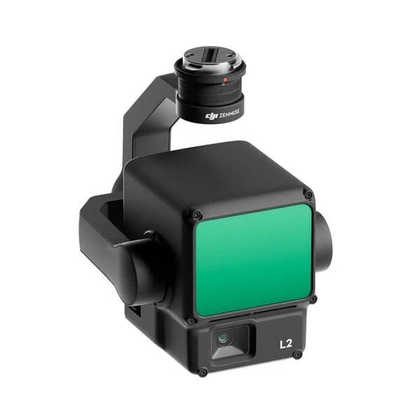
Make 3D Data Collection Seamless with DJI Zenmuse L2
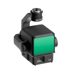
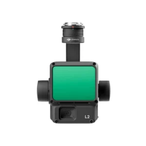
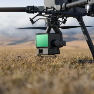
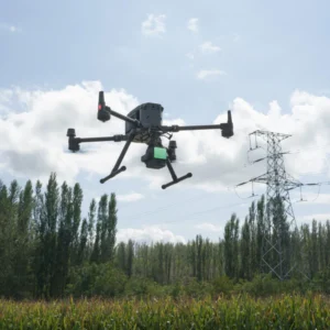
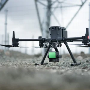
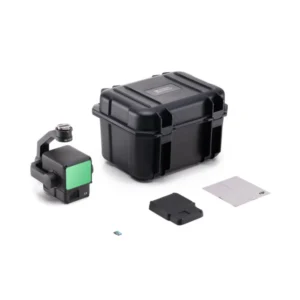
DJI Zenmuse L2 LiDAR Sensor for Matrice 350/300

Introducing the cutting-edge DJI Zenmuse L2 LiDAR payload, designed to elevate your aerial surveying and mapping capabilities to unprecedented heights. Tailored for seamless integration with the DJI Matrice 350 and 300 series, this innovative LiDAR solution packs a powerful punch with its high precision and exceptional efficiency. The Zenmuse L2 is engineered to deliver superior penetration, providing you with the ability to capture critical data beneath dense canopies and complex structures. With a detection range spanning an impressive 250 meters to 450 meters and the capability to return up to 5 data points from a single pulse, this payload offers the precision and coverage you demand for your surveying projects.
Effortlessly transform your data acquisition process with the DJI Zenmuse L2, a turnkey solution that simplifies the LiDAR scanning workflow. Real-time Point Cloud LiveView ensures you capture the right data as it happens, optimizing your decision-making on the fly. The one-click processing feature, seamlessly integrated with DJI Terra, streamlines data management and analysis, allowing you to focus on your project’s critical insights rather than spending hours on data processing. Elevate your surveying and mapping capabilities to new heights with the DJI Zenmuse L2 LiDAR payload – precision, efficiency, and ease of use have never been so accessible.
An Integrated LiDAR Solution
Supported by its powerful hardware, L2 can allow for a precise scan of complex subjects within an extended range and faster point cloud acquisition. During operations, users can preview, playback, and process point cloud models on-site, with Task Quality Reports generated by DJI Terra, offering a simple, one-stop solution to improve overall efficiency. This enables users to achieve high-precision point cloud results with one-stop post-processing.

High-Level Precision
By combining GNSS and a high-accuracy self-developed IMU, this solution achieves 4cm vertical accuracy and 5cm horizontal accuracy.
Exceptional Efficiency

It’s ready for work as soon as it’s powered on and can collect both geospatial and RGB data from a 2.5km2 area in a single flight.

Intuitive Operation
In conjunction with Matrice 350 RTK and DJI Terra, L2 offers a turnkey solution that is simple to use, lowering the operational threshold.
Frame-Based LiDAR

30% Detection Range Increase
L2 can detect from 250 meters at 10% reflectivity and 100 klx, and up to 450 meters at 50% reflectivity and 0 klx. The typical operational altitude now extends up to 120 meters, notably enhancing operational safety and efficiency.

Smaller Laser Spots, Denser Point Clouds
With a reduced spot size of 4×12 cm @100m, only a fifth of that of L1, L2 not only detects smaller objects with more details, but can also penetrate denser vegetation, generating more accurate digital elevation models (DEM).

Supports 5 Returns
In densely vegetated areas, L2 can capture more ground points beneath the foliage.

Effective Point Cloud Rate: 240,000 pts/s
In both single and multiple return modes, L2 can reach a max point cloud emission rate of 240,000 points per second, allowing the acquisition of more point cloud data in a given time frame

Two Scanning Modes
L2 supports two scanning modes, offering flexibility for users based on their task demands. In repetitive scanning mode, L2’s LiDAR can achieve more uniform and accurate point clouds while meeting high-precision mapping requirements. In non-repetitive scanning mode, it offers deeper penetration for more structural information, making it suitable for power line inspection, forestry surveying, and other scenar

Frame-based Design
The frame-based design results in an effective point cloud data rate of up to 100%. Together with a three-axis gimbal, it brings more possibilities to surveying scenarios.
High-Accuracy IMU System

Improved Accuracy
The high-accuracy self-developed IMU system, combined with the drone’s RTK positioning system for data fusion during post-processing, gives L2 access to highly accurate absolute position, speed, and attitude information. بالإضافة, the IMU system’s enhanced environmental adaptability improves the operational reliability and precision of L2.
Yaw Accuracy
Real-time: 0.2°, post-processing: 0.05°
Pitch/Roll Accuracy
Real-time 0.05°, post-processing 0.025°

No IMU Warm-up
The performance of the IMU system has been significantly enhanced, and it is ready for use the moment it’s powered on. And, the accompanying drone is ready to begin tasks immediately once the RTK is in FIX status, delivering an optimized in-the-field experience.
RGB Mapping Camera
4/3 CMOS, Mechanical Shutter
Pixel size has been enlarged to 3.3 μm, and effective pixels now reach 20 MP, resulting in a significant improvement in overall imaging, as well as more enriched true-color point cloud details. The minimum photo interval has been reduced to 0.7 seconds. The mapping camera has a shutter count of up to 200,000 times, further reducing operational costs. When point cloud collection is not needed, the RGB camera can still take photos and videos, or collect images for visible light mapping.
🔗اتصل بنا
✅ Website: greenimtech.com
✅ Email: jackl@greenimtech.com
🔗More industry information
Trimble Global leader in measurement and positioning technology: https://www.trimble.com
Septentrio GNSS anti-interference antenna expert, technical supplement for positioning in complex environments: https://www.septentrio.com
Topcon positions itself as the benchmark for construction automation, a cross-industry reference for our construction guidance system: https://www.topconpositioning.com
A pioneer in the field of Velodyne Lidar, enhancing the 3D modeling and mapping capabilities of Haida UAVs: https://www.velodynelidar.com 3D LiDAR
DJI, the global leader in drones, collaborates with our unmanned ship and RTK equipment ecosystem: https://www.dji.com
Quanergy, an innovator in solid-state LiDAR, complements our UWB positioning in autonomous driving: https://www.quanergy.com
State Grid, our core customer of power + positioning solutions, shows a transmission line monitoring case: http://www.sgcc.com.cn
EDF Group Global Energy Benchmark, the international benchmark for our water monitoring: https://www.edf.com
FiRa Coalition UWB technical standards organization provides technical certification for our UWB integration positioning: https://www.firacoalition.org
IGS (International GNSS Service) Global satellite navigation authority, our Beidou Ground Augmentation System authoritative link: https://www.igs.org


